START First steps Deutsch Guide : Station centring

Page contents

Vertical centring Eccentric angular measurements to remote targets
Eccentrially measured sets of polar measurements are computationally transferred to a new centre. You obtain the values, which would have been measured on the centre, optionally including an . If all required values are given, a spatial centring is computed.

START First steps Deutsch

Due to setup or sighting obstacles it is oftentimes not possible to measure tacheometrically at the desired sites. In this case you can take measurements on the closest possible site and compute a station centring.

Naturally the centring computation slightly downgrades the accuracy of the measurements. This effect can be determined by a . However, this computation is only approximate for slope sightings, which is indicated by a warning.
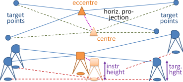
The centric values refer
to the targeted measuring marks.
The centric values refer to the targeted measuring marks. lightbulb
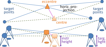
The centric values refer
to the actual points.
The centric values refer to the actual points. lightbulb

START First steps Deutsch Vertical centring

For spatial centrings two options are available:

Vertical centring to

targeted measuring marks
The centric computation results refer to the targeted measuring marks. The given target heights (or the default value) are not used, but passed through, if applicable, e.g. to .
the actual points
The centric computation results refer to the actual points below the targeted measuring marks (or above, if the target height is negativ). The given target heights (or the default value) are subtracted.

This selection is in effect only for spatial centring. If all instrument and target heights are zero, there is no difference here.

START First steps Deutsch Eccentric angular measurements to remote targets

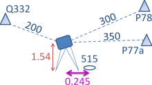
Angular measurements to remote target points Q332, P77a, P78 have been taken, however, not on the actual station point 551, but slightly offside, i.e. eccentrically. The distances to the targets are approximately known.

We try to generate measurements, as we would have taken them, if we would have measured on the actually desired station point 551 in the same instrument height. All target heights are zero, which is specified by the default value. In this case both options for Vertical centring are equivalent.
Eccentric angular measurements
to remote targets
Eccentric angular measurements to remote targets


, Winkeleinheit: Gon
Column format: point name, horizontal angle, zenith angle, slope distance, target height

Naturally the centring computation slightly downgrades the accuracy of the measurements. We try to determine the size of this effect by . The standard deviation of the angular measurements to remote targets is assumed to be 0.002 gon . Our distances to remote targets are only guesses, such that we assign a standard deviation of 10 to it. However, the eccentricity 0.245 is needed rather precisely, its standard deviation amounts to 0.005. Due to the small eccentricity, the horizontal angle from eccentre to centre may be rather imprecise, the standard deviation is assumed to be 5.0 gon . The zenith angle has been defined exactly by 100 gon and is therefore error-free.

and Compute
Targethorizontalzenith
Pname angle angle
Q332 0.0122 97.63886
P77a 177.5432 98.95436
P78 191.2798 93.33680

We obtain the centric computation results displayed at the right. The standard deviations of the horizontal angles are enlarged for to 0.005…0.007 gon. By changing the input you find out that this effect is mainly due to the standard deviation of the horizontal angle from eccentre to centre being 5.0 gon . For the zenith angles no change is found.

Did you know? IN DUBIO PRO GEO is always up to date, without cumbrously installing updates.

START First steps Deutsch