A planar polygon is a planar curve consisting of straight line segments (sides). It is defined by a sequence of vertices in a plane joined by sides. A polygon may be closed or open . In the first case the last and the first vertex are connected by an side, such that the polygon bounds a planar piece of surface. In the second case the polygon is called a polyline. The vertices are given as a coordinate list , which also defines the succession of points.
Cartesian systems (XY or YX): A Z coordinate is ignored, if any, while a warning is issued. This means that the points are projected onto a horizontal plane and are treated as polygonal vertices there.
Grid systems (Northing Easting or Easting Northing): Heights, if present, are used to compute the grid scale . Consequently the polygon is computed in the horizontal grid plane at the mean height of all points with specified heights (or at zero height if all heights are missing). For all lengths and for the area the grid scale is applied. If you desire to compute the polygon at zero height, then all heights must be set to zero or omitted. (In German real estate affairs the sizes of areas refer to zero height.)
Ellipsoidal systems (Longitude Latitude or Latitude Longitude) are not directly applicable, but require a .

See also types of coordinate system.
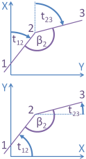
Polygonal angles are always located right of the polygon and may for the closed polygon be internal angles (moving clockwise) or external angles (moving counterclockwise).
Azimuthal angles, also known as azimuths, are angles from the X or northing axis to the polygonal sides in moving direction. The sense of rotation is counterclockwise for the cartesian righthanded system and clockwise for all other types of system. Therefore, the X or northing axis has azimuth zero and the Y or easting axis has azimuth 90° = 100 gon.
Special points, i.e. barycentres and circle centres are computed only is possible. The barycentre of area is the centre of mass of the area of the closed polygon. The barycentre of sides is the centre of mass of the sides of the polygon. The barycentre of vertices is the centre of mass of the vertices of the polygon. The centres and radius of the circumscribed and inscribed circles are only computed for closed triangles. (For other polygons such circles do in general not exist.) All those computed coordinates refer to the system of the given coordinates of the vertices.
The barycentre of area of the polygon crossing itself can be situated very much outside the polygon and is practically rarely useful.

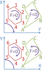
The size of area refers to the polygon. The following sign rule is established:
| size of | sequence of vertices | polygon crosses | |
|---|---|---|---|
| area F | clockwise | counterclockwise | itself |
| lefthanded | F > 0 | F < 0 | difference of the area |
| righthanded | F < 0 | F > 0 | segments is obtained |
The polygonal diameter equals the maximum distance of all pairs of vertices. Example: The polygonal diameter of a rectangle equals the diagonal.
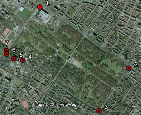
The Großer Garten Dresden
has been surrounded by a polygon consisting of seven vertices.
For those vertices the UTM coordinates (zone 33U) have been determined.
The succession has been chosen clockwise, in order to get the area positive and the polygonal
angles are internal angles of the polygon.

The computation of the polygon results in an area of 1811260 m² ≈ 1.8 km² and a perimeter of 5767 m . The longest polygonal side is the side 1-2, it has the length 1903 m . Opposite sides differ in the azimuth by about π = 180° = 200 gon, they are therefore nearly parallel. At the sides 1,2,3 the internal angles are nearly right angles. The vertices with the largest distance are 2 and 7, it amounts to 2174 m.
Heights have been omitted in this example. Therefore, lengths and areas refer to the sea level. The Großer Garten has a mean height of approximately 120 m. We could tentatively add height values 120 to the vertex coordinates. (One would be enough because for the. grid scale is deduced from the mean of all specified heights.) The new size of the area at ground level of 1811328 m² turns out to be 68 m² larger than the area at sea level. This height effect seems to be significant. However, if we add 1 m to the northing of side 1 then we get an area at sea level of 1812341 m². This increase by far exceeds the previous one.
Due to this change of height the lengths increase by some centimetres. The perimeter increases e.g. by 0.11 m . Angles and coordinates of barycentre do not change. Since the sides are not defined with metre accuracy here, it is not mandatory to use heights in this computation.

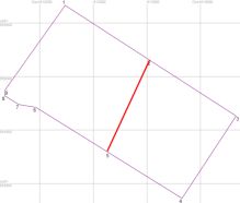
We add the midpoints of the two long polygonal sides as new vertices and recompute. At these points the polygonal angles amount to π = 180° = 200 gon. The side lengths are cut into halves. The other values do not change. However, if you divide the closed polygon along the line through both midpoints into a western and an eastern partial polygon, by deleting or commenting out (i.e. prepending '//') the remaining points in the coordinate list , and compute those partial polygons separately, then you recognize that in the western part the sides shrink by up to 1 mm and in the eastern part they stretch by up to 1 mm. The sum of the areas of both partial polygons is smaller than the area of the total polygon by 0.023 m² . The reason is that during all computations a constant grid scale of the polygons has been assumed. When splitting the area, this approximation is enhanced.
Here, this deviation is comparatively small, because Dresden is situated close to the central meridian.
and
also compute a circle through three points, this is the case if the closed planar or
spatial polygon consists of exactly three points. Below
Special points
you find the centre of the circumscribed circle
M3
and the radius of this circle. By the way, the same applies to the centre of the inscribed circle
M4
and the corresponding radius.
|
|
|
|